Culture of Clown fish
Clown fishes are maintained in our hatchery .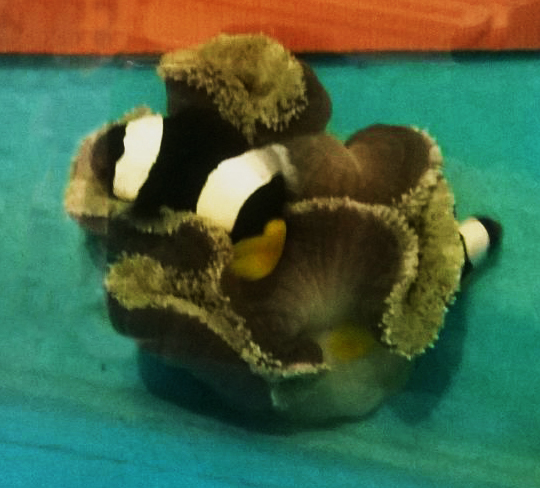
Clown fishes are maintained in our hatchery .
Nursery had been raised for 1000 saplings of two different species namely Avicennia and Rhizophora. The size of polythene bags varied as per the size of the seeds. Rhizophora needed longer bags than any other. All the bags filled with clay soil and seeds were dropped inside it. They had been maintained with regular watering (mixed water of sea and fresh water). Germination of Avicennia was faster than the Rhizophora. After three months, saplings were ready for planting in the site. When the saplings attained appropriate growth (after 3-4 months), they were transferred into the plantation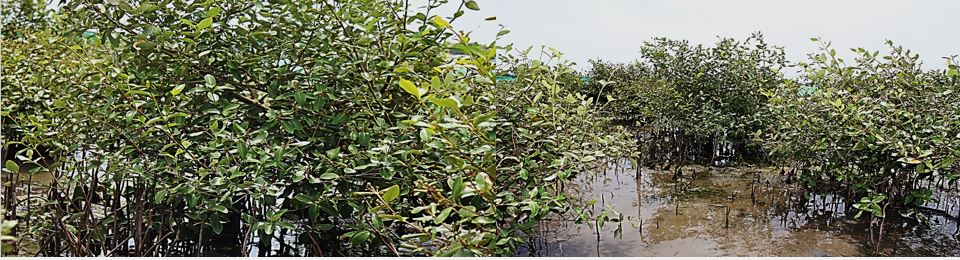 site.
site.
The sapling were planted at prepared hole for planting about 1.5 times wider and 1.5 times deeper than the root ball of the seedling. When placing the seedling in the prepared hole, care was taken in such a way that the top of the root ball is even with the surface of the soil. It is also important that the roots be allowed to dangle freely, straight into the hole. 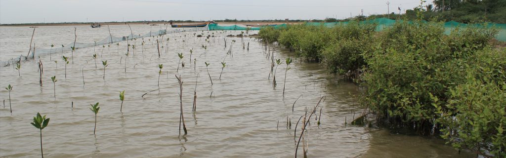
Roots in contact with the bottom of the hole normally curl upward which may stunt growth or even kill the sapling. After planting the sapling, hole was lightly back filled with soil in order to create the small air packets which may facilitate the easy penetration of roots. Holes were made with the spacing of 2 meters in all around for proper growth of mangrove seedlings. The entire plantation was made by service learning process through students and local peoples
 In the present study, a total of 156 species were recorded for both the years. Of this 46 species of Polychaetes, 16 species of Oligochaetes, 8 species of Tanaids, 18 species of Amphipods, 14 species of Isopods, 15 species of Nematodes, 9 species of Turbellarians, 3 species of Gastropods, 5 species of copepods, 2 species of Lorcifera, 3 species of Kinorhyncha, 4 species of ostracoda, 2 species of Tardigrade , 6 species of cumacea, 4 species of Bivalves and one species of Scalopod were recorded. Cerethidium cingulata, Bullia tranqubarica, Meretrix meretrix,
 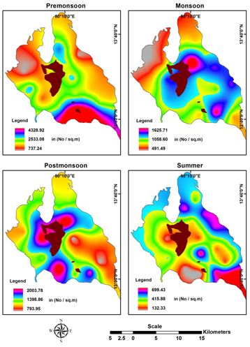 Villorita cyprinoides, Heteromastus filiformis, Mediomastus capensis, Cirratulus filiformis, Apseudes spinosus and Apseudes gymnophobia were occurred in most of the stations of the Pulicat Lake in irrespective of seasons. Polychaetes and tanadiceans were dominant in terms of diversity and density (Fig. 68). All other species were less dominant. In meiofauna, nematodes were dominant than other groups in the study. Temporal variation also found in the benthic faunal groups which explained that 2010-2011 year had increased faunal density and diversity compared to the year 2009-2010. The reason might be owing to high precipitation which caused nutrient supplement to the lake. But Tanaids alone had reduction in the population in the year 2010-2011 than the previous year. It might be due to in situ production of nutrients which are lacked in 2010 -2011. The supplement of nutrient is strictly from terrigenious in 2010 -2011.The population density of benthic fauna varied from 4328.92 in St-16 to 132.33 in St-16 No/Sq.m for the year 2009-10 and for the year 2010-11, the population density varied from 1871.46 in St-2 to 132.33 in St-6 No/Sq.m. The density was high in Pre Monsoon and very low in Summer for both the years. The seasonal trend in the species density is found to be same for both the years of investigation. Comparatively benthos were enriched in 2009 -2010
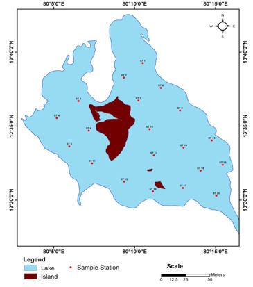
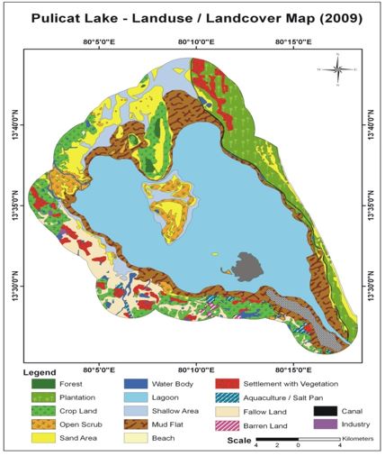 Pulicat lake is the second largest brackishwater lake in India and is located between 13o26’ and 13o43’N latitude and 80o03’ and 80o18’E longitudes. The recent estimation showed that the lake might have originated 6,660 years ago during the Holocene geological period. The dried parts of the lagoon is extend up to 13O60’ N latitude. The lake is lying almost parallel to the Bay of Bengal and opens to it through the south-eastern channel which is narrowest region near the Pulicat (Pazhaverkadu) village measuring about 250m. It covers an area of about 461 km2. The lake extends to about 59km from north to south direction with a maximum width of 19 km in east – west direction in the northern sector of the lake. The average depth of the lake is about 1.5m and the minimum and maximum depth varies between 0.5 to 6.0m respectively. Tidal fluctuation within the lake is 0.6m. The hydrodynamic characteristics of the lake are restricted to lagoon-ocean water exchange and seasonal positional switching of the entrance channel is the predominant issue. Within the lagoon, sediment may be transported by wind-induced waves and currents directed predominantly towards the northeast and west direction. The evaporation rate exceeds precipitation and runoff.Pulicat landuse and landcover map been prepared to evaluate the resources and its utilization. The land cover comprises forest area 0.9 sq km, mud flat 162 sq km, Plantation 92.7 sq km, sandy beach 17.7 sq km salt pan 0.07 sq km, water body 139 sq km. The mudflat spreads are higher next to water holding area in the lake. The vast mudflat area, around the lake is an ideal feeding ground for migratory birds as it supports rich assemblage of seaweeds and sea grasses. Barren mudflats have high potential to arise the mangrove plants with participatory approach. Shell mining is the serious threat to the resources and alteration of habitat in the lagoon of Pulicat.
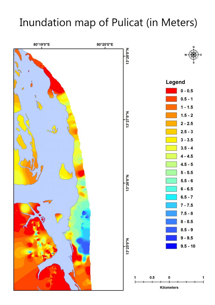 The present study has generated results helped to carry out tsunami vulnerability assessment. Map represents the submergence level of study area from 0-10 m. If the water level rises from 0-0.5m can cause submergence along Pulicat settlement, jamilapath and saathankuppam village. These two areas are highly prone to inundation. And near to the mouth region is also submersible when the water level rise as 0-0.5m. If the water level rises from 0.5-1 m can cause submergence extended to saathankuppam village and Pulicat settlement and mouth region. If the water level rises up to 1-1.5m, the region adjutant to the back water of Pulicat and saathankupam village, karimanal village can be easily submersed.
The Pulicat market area, area adjustant to jamilabath settlement, sathankuppam and vairavam kuppam area can be easily submersed if the water level rises to 1.5-2m. If the water level rises up to 2-2.5m it would cause inundation along the saathankuppam and some of the Pulicat region. If the water level rises up to 2.5-3m which causes inundation along the settlement area of light house kuppam and some of the settlement area of saathankuppam. If  the water level rises up to 3-3.5m it makes inundation along the land area of Pulicat and area which is near to the lake in Northern side. 3.5-4m water level rises can cause submergence along the Pulicat and in adjustant to lake and lighthouse kuppam. 4-4.5m of water level rises can cause inundation along settlement area of Lighthouse kuppam. If the water level rises up to 4.5-5m, the karimanl village and the Nakathur village would be submerged. 5-6m water level raises would inundate along the Nakathur village. 6-7m, represents the submergence level adjustant to Nakathur village. If the water level rises up to 7-7.5 m which cause inundation near vairavam kuppam and 7.5-8m water level rises can inundate the settlement area of vairava kuppam. If the water level rises up to 8-10m, the Vairavan kuppam and adjutant to karangali village can be easily submersed. The highly elevated area was observed in vairavam kuppam and the lowest area was noticed in saathankuppam and jamilabath village which are highly prone for the tsunami waves. These villages can be easily submerged even if the water level rises up to 0.5m.
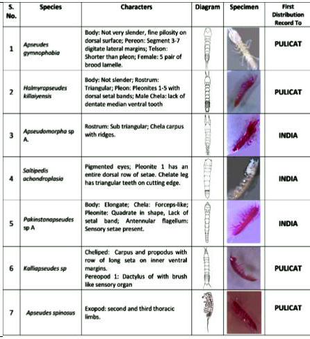
Tanaids constitute an important component of coastal communities, as they found in wide variety of marine and brackish water habitats. They are good micro scavengers, eating detritus and food particles thereby proliferate in abundance and in turn act as an excellent food resource for higher trophic level including significant point source of food for fishes, crustaceans and benthic organisms of commercial and aesthetic value. A total of seven tanaids were recorded from suborder Apseudomorpha represented by four families in Pulicat coastal lake. Among, two species namely Apseudes gymnophobia (Pagurapseudopsis gymnophobia) and Apseudes chilikensis were recorded from family Apseudidae. Three species namely Halmyrapseudes killaiyensis, Saltipedis achondroplasia and Pakistanapseudes sp. A were recorded from family Parapseudidae. Other two species Apseudomorpha sp. A from family Metapseudidae and Kalliapseudes sp from family Kalliapseudidae. Among the seven species, three species namely Apseudes gymnophobia, Apseudes chilkensis and Halmyrapseudes killaiyensis were found in all twenty stations. Saltipedis achondroplasia represented in 14 stations. Pakistanapseudes sp. A represented in 8 stations. 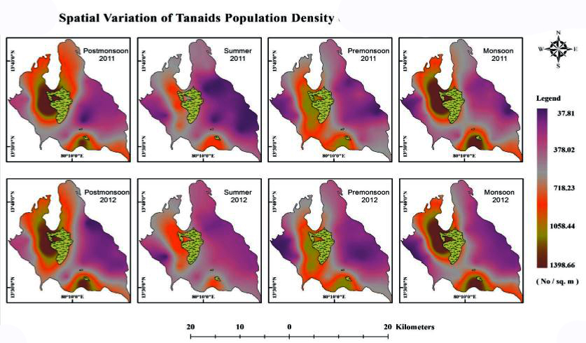 Apseudomorpha sp. A and Kalliapseudes sp were found in seven and five stations respectively. Stations such as St.1, St.6, St.7, St.17 and St.20 recorded with six species. St.2, St.10, St.11, St.16, St.18 and St.19 were recorded with five species. St.3, St.5, St.8, St.9, St.12, St.13 and St.14 were observed with four species and St.4 and St.15 noticed to have three species. Among the seven species, the most dominant one was Apseudes gymnophobia (31%) followed by Halmyrapseudes killaiyensis (28%), Apseudes chilkensis (24%), Saltipedis achondroplasia (10 %), Pakistanapseudes and Apseudomorpha (3 % each) and Kalliapseudes sp (1 %). The population density ranged from 38 no/sq. m to 399 no/ sq. m with mean population density of 623 no/ sq. m. The diversity of the tanaids population varied from 1.109 to 1.384. Evenness of the tanaids differentiated from 0.8 to 1. Species richness deviated from 0.54 to 0.96. Current study on tanaidacea perform key ecological role in the coastal lake ecosystem. The spatial and temporal distribution of tanaids are strongly influenced by physico-chemical parameters, seasons, substratum and its characters.
Totally ten species were identified. Heteromastus filiformis, Mediomastus capensis, Capitella capitata, Namalycastis siolii, Namanereis quadraticeps, Microneredies capensis, Unanereis macgregori, Marphysa graveli, Mystides angolansis Armandia longicudata, Among, three species namely Heteromastus filiformis, Mediomastus capensis, Capitella capitata, were recorded from family Capitellidae. Four species namely Namalycastis siolii, Namanereis quadraticeps, Microneredies capensis, Unanereis macgregori, from the family Nereidae. One species namely, Marphysa gravelyi, were recorded from family Eucinidae, Mystides angolansis from the family Phyllodocidae and Armandia longicudata, from the family Ophellidae. Among the ten species, two species namely Heteromastus filiformis and Armandia longicudata were found in all twenty stations. Mediomastus capensis represented in 10 stations. Capitella capitata and Namanereis quadraticeps represented in 8 stations. Marphysa gravelyi were found in seven stations. Namalycastis siolii were found in six stations. Microneredies capensis and Mystides angolansis were represented in two stations . Unanereis macgregori were found in only one station. Stations 1, 4, 5, 11, 12, 13, 14, 16 and 20 recorded with four species. St. 2, 7, 9, 10, 17, 18 were recorded with five species. St. 3, 6, 8 and 19 were observed with three species and St. 15 have six species.
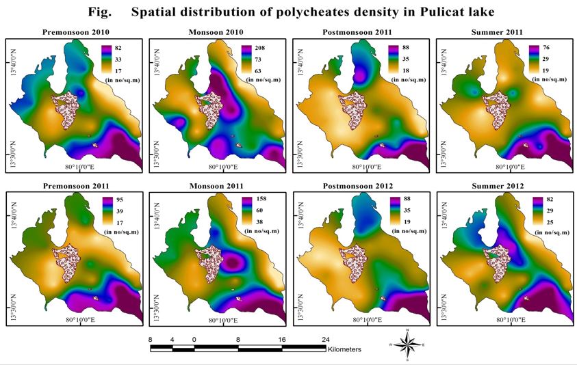 Among the ten species, the most dominant one was Armandia longicudata (43.38%) followed by Heteromastus filiformis(17.38%), Marphysa gravelyi (17.31%), Mediomastus capensis (5.84%), Namanereis quadraticeps(5.50%), Capitella capitata(4.55 %), Namalycastis siolii (4.14%), Mystides angolansis (1.09%), Microneredies capensis (0.48%) and Unanereis macgregori(0.34 %). The population density ranged from 17 no/sq.m to 208 no/sq.m and with mean population density of 58 no/sq.m. The diversity of polychaetes population varied from 1.96 to 2.456. Evenness of polychaetes differentiated from 0.79 to 0.99. Species richness deviated from 1.54 to 1.87. Hydrography, seaweeds and grasses cover, organic materials, nutrients, are the major factors influencing polychaetes density in Pulicat. Southern part of the lake had flourishing seaweeds and grasses and St.2 at Northern part of the lake found to be dominant of polychaetes where silt, organic carbon prevailed more during monsoon seasons.
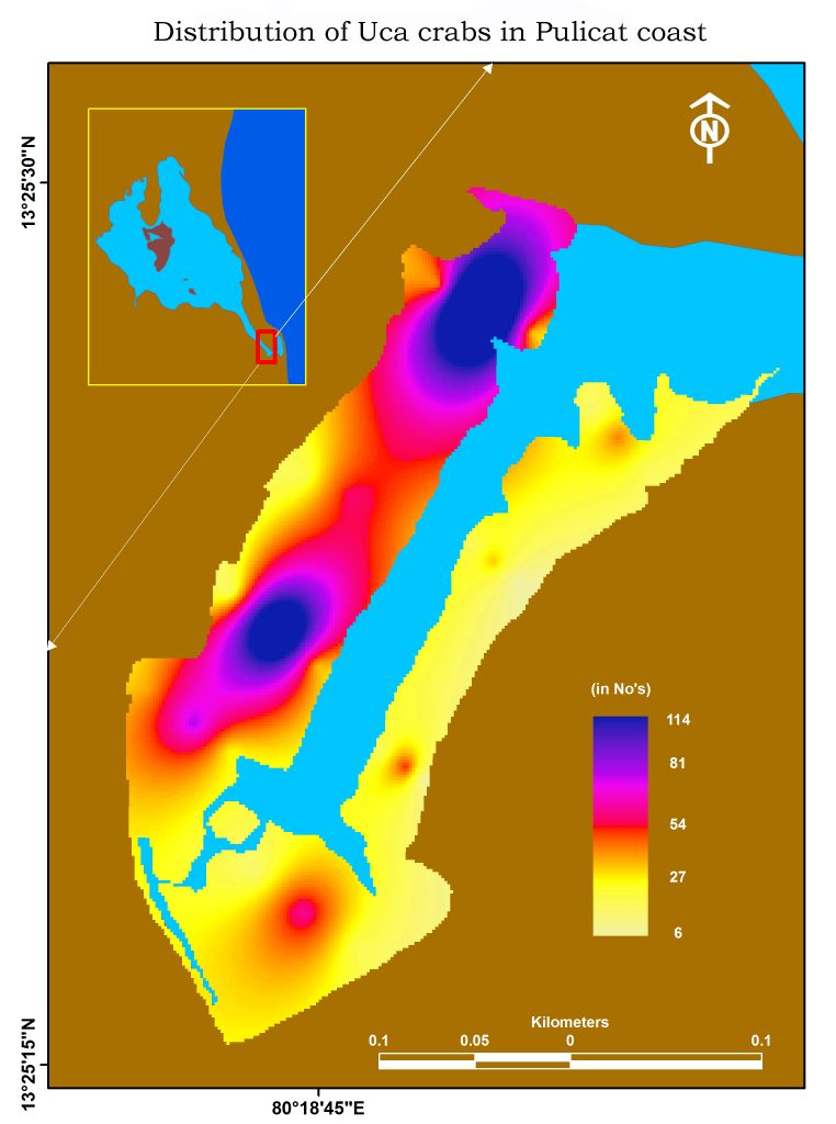 Twelve species of brackish water brachyuran were identified in major landing centers of Pulicat Lake They are Scylla serrata, Scylla tranqueberica, Matuta lunaris, Thalamita crenta, Chayribdis natator, Chayribdis feriatus, Portunas pelagicus, Portunas sanguinolentus, Uca annuplies, uca triangularis, Cardisoma carnifex, Diogenes avarus. There are two Uca species were identified in Pulicat. They are Uca annulipes and Uca triangularis. Density of fiddler crabs varied from 6 to 114 no /sq. meter. Measurement of burrow was observed with the presence of hoods, dimension, angle of decent of holes and burrow depth were noticed. Claw wavings were observed. There are 4 types of claw waving were noticed such as lateral circular waving, lateral flick waving, Rapid vertical waving, circular waving. Colour variation of the uca were noticed . The colour variation in the carapace of uca occurs according to the increase in temperature. Colour of the uca increases, when the temperature increases.Variation of temperature, Salinity and pH from 28.9 to 32.8 OC, 14 to 26 ppt and 6.6 to 7.5
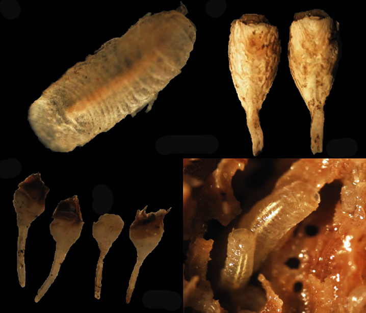 Four different types of fouling organisms were encountered in Pulicat Lake. They are Balanus amphirite, Balanus verticulatus, Cellana radiate and Crassostrae madarassensis. Balanus amphirite is the dominant species followed by balanus verticulatus, cellana radiate and oyster. Pillar has more prone to fouling by marine organisms than wood (boat). Maximum number of attachment by fouling organisms is 26 nos/ 5 sq. cms and the minimum is 4 nos/ 5 sq. cms. The weight of the fouling organisms between pillar and boat, boat and wood noticed to have higher weight of the fouling organisms.Though density of fouling organisms were high in pillar and concrete structures, weight of the organisms were low. Comparing length measurement of fouling organisms in both pillar and wood revealed that most of the fouling organisms are lesser length in pillar than boat. Experiment was carried out to check the fouling activity on temporal basis in Pulicat. Same sized wood and stone was selected. In the wood one was chosen for control and the other one painted with tar and later one painted with paints. Same setup was maintained in wood too. They were hanged in the water column for the period of 45 days. All materials have elevated weight due to primary line attachment. Control sample of wood have found with some minute fouling organisms mainly barnacles.There are three types of boring organisms were encountered in Pulicat lake. Glycera alba, Barnea birmanica and Bankia rochi. Boring organisms varied from 16 (wood 1, 3rd quadrate) to 24 (wood 4, 4rd quadrate) Nos / sq. meter (Fig 8). Wood borers were in high dense in wood 2 and low in wood no 5. Quadrate wise, borer density was higher in 4th quadrate and lesser in 2nd quadrate.