Geomorphology of Pulicat
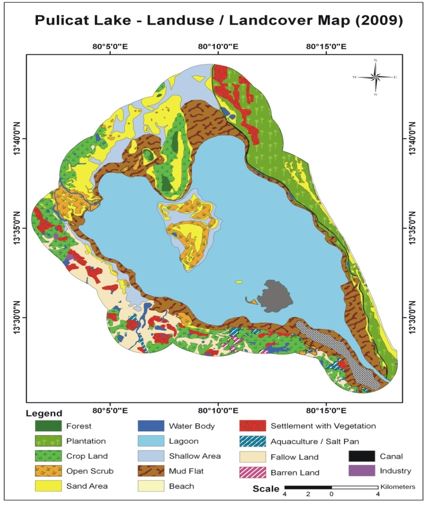 Pulicat lake is the second largest brackishwater lake in India and is located between 13o26’ and 13o43’N latitude and 80o03’ and 80o18’E longitudes. The recent estimation showed that the lake might have originated 6,660 years ago during the Holocene geological period. The dried parts of the lagoon is extend up to 13O60’ N latitude. The lake is lying almost parallel to the Bay of Bengal and opens to it through the south-eastern channel which is narrowest region near the Pulicat (Pazhaverkadu) village measuring about 250m. It covers an area of about 461 km2. The lake extends to about 59km from north to south direction with a maximum width of 19 km in east – west direction in the northern sector of the lake. The average depth of the lake is about 1.5m and the minimum and maximum depth varies between 0.5 to 6.0m respectively. Tidal fluctuation within the lake is 0.6m. The hydrodynamic characteristics of the lake are restricted to lagoon-ocean water exchange and seasonal positional switching of the entrance channel is the predominant issue. Within the lagoon, sediment may be transported by wind-induced waves and currents directed predominantly towards the northeast and west direction. The evaporation rate exceeds precipitation and runoff.Pulicat landuse and landcover map been prepared to evaluate the resources and its utilization. The land cover comprises forest area 0.9 sq km, mud flat 162 sq km, Plantation 92.7 sq km, sandy beach 17.7 sq km salt pan 0.07 sq km, water body 139 sq km. The mudflat spreads are higher next to water holding area in the lake. The vast mudflat area, around the lake is an ideal feeding ground for migratory birds as it supports rich assemblage of seaweeds and sea grasses. Barren mudflats have high potential to arise the mangrove plants with participatory approach. Shell mining is the serious threat to the resources and alteration of habitat in the lagoon of Pulicat.